Seadrift History
by Ellen McElhinny
Roots in the Sand: a Seadrift History
The history of Seadrift—a housing community built along a mile-long sandspit—is a fascinating story that many of us have yet to discover. Because it is a fairly recent development (dating from the 1950s onward), there are many people in our community who still hold firsthand memories and stories of its evolution. The Seadrift Association also maintains thorough records that help piece this narrative together.
As a cultural geographer who built a house here 30 years ago, I have always been interested in why landscapes look the way they do and how they develop over time. When Jean Gould asked me to write a few chapters on the development of Seadrift for the newsletter, I was happy to dive in. It has been endlessly interesting to talk to neighbors about the original gate, the early beach houses, the dredging and expansion of lots, our major storms, and the installation of the riprap along the beach.
Because of how Seadrift is situated, I refer to the direction of the office as "East." I welcome new stories and, of course, any corrections!
It all Started Here
The sandspit known as Seadrift today has had an interesting and somewhat complicated history. In many ways, it mirrors events in California over the last 150 years; in others, it tells the story of the beautiful, unique place many of us call home.
Seadrift developed later than any of the other neighborhoods in West Marin: Bolinas, Point Reyes Station, Dogtown, and even Stinson Beach. It is helpful to understand the history of the area to recognize why it was so many years before the first structure was built on the spit.
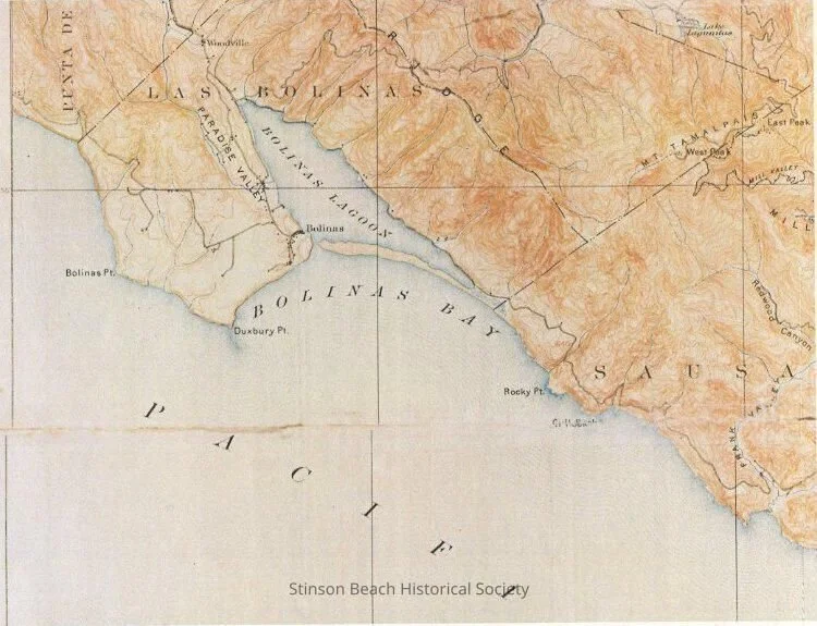
The Bolinas Lagoon is a tidal estuary and a drowned section of the San Andreas Fault; Tomales Bay marks the northern end. The Point Reyes Peninsula moves north as the rest of California moves south. The fault runs primarily along Highway One from Point Reyes to Stinson Beach, cutting across Kent Island and the end of the sandspit before heading out into the Pacific. It skips San Francisco, coming ashore further south near Pacifica.
Our sandspit is a curved sandbar that developed along the Bolinas Lagoon. Sandspits form through a process called longshore drift: waves arrive at the shore at an oblique angle, carrying sediment or sand. One of the remarkable things about Stinson and Seadrift beaches is that they face south, rather than west like most of the California coast. The Bolinas coast, starting at Agate Beach, faces west; when the coastline sharply changes direction, the water’s energy decreases and it drops its sediment load. This builds up a sandspit growing outward from the land, which in turn provides a calm, sheltered area behind it—the Bolinas Lagoon.

Aerial view of the Bolinas Lagoon and San Andreas Fault. Courtesy of the Stinson Beach Historical Society.
In the 1850s, Briones sold land from his grant (including the sandspit acreage) to Capt. Isaac Morgan, who established an apple farm along the east side of the Bolinas Lagoon. Fifty years later, Nathan Stinson and James Wallace bought the 1,720 acres—including the sandspit—from Morgan.
California’s population boomed during the Gold Rush years, creating a demand for supplies including lumber and food. While the area that would become Stinson Beach remained undeveloped (it was simply too difficult to access), Bolinas grew thanks to its navigable harbor. Lumber from the hills and dairy and agricultural products from the ranches were shipped from there to burgeoning San Francisco.
USGS Survey Tamalpais Sheet 1897. Courtesy of the Stinson Beach Historical Society.
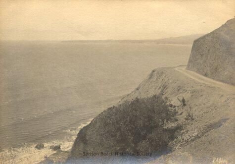
That all changed with a new—albeit dirt—road over the hill from Sausalito and the promise of a new railroad. In 1870, the “Outside Road” (following much of today’s Highway One route) was built from Sausalito to Bolinas, running right through Stinson. This 12-mile road opened up Stinson Beach as a resort town; the sandspit, however, remained largely undeveloped and uninhabited for another 50 years.
Outside road, 1870. Courtesy of the Stinson Beach Historical Society.
Sandspits are considered highly unstable due to tides, storms, and changes in sediment load. (I’m a cultural geographer, not a physical one, but the spit appears to be somewhat of a temporary geological phenomenon. No worries.)
Until the development of Seadrift, the sandspit remained a mile-long, largely unvegetated, low tract of land with almost no change. High tides and winter storms regularly washed ocean waves over the spit and into the Bolinas Lagoon.
Coast Miwok people lived in the West Marin area for 3,000 years. They did not leave any visible marks on the sandspit. In 1836, Mexico issued a land grant called Rancho Las Baulines to Rafael Garcia; this included land stretching from present-day Dogtown to Stinson Beach and the sandspit, and from the Bolinas Ridge to the ocean and Bolinas. These lands were then deeded to Gregorio Briones in 1846.
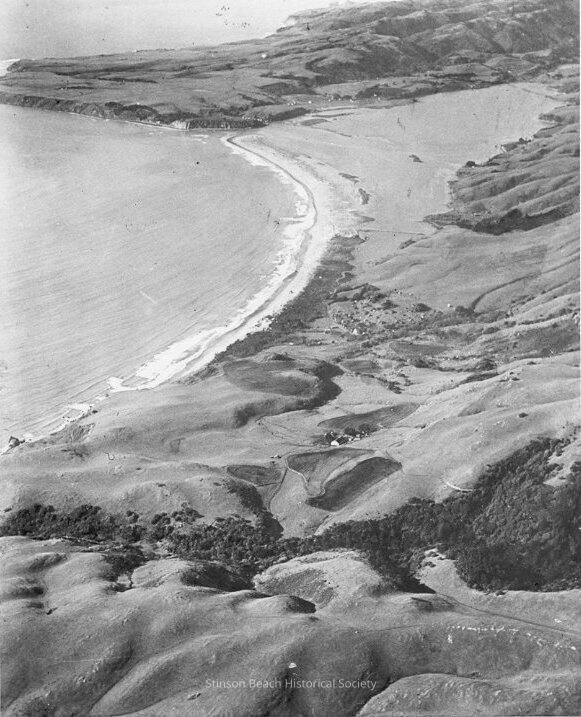
Undeveloped sandspit, 1910. Courtesy of the Stinson Beach Historical Society.
A Railroad to Seadrift?
The first road connecting Stinson Beach to the outside world was constructed in 1870. It was a narrow dirt road with ‘exciting’ curves. Panoramic Highway was not completed until 1928.
The four-mile-long swimming beach was one of the best beaches in Northern California, and it was now a bit more accessible. By 1879, 20 family tents had been constructed on Easkoot’s Beach, along today’s Calles. Visitors could hike over the hill, take a boat to Bolinas, ride a horse from Olema, or soon a horse drawn stagecoach. A competing tent hotel called Willow Camp (the early name of Stinson) was built in 1880. These tent camps with their basic facilities were followed by a number of hotels and restaurants in town. Lodging and restaurants were clustered downtown and along the Calles. While the town expanded, the sandspit remained pristine.
The Kent family has played a large sized historical role in purchasing land in Marin County, both to preserve some significant open spaces and to develop others.
Albert Kent, after making his fortune in the meatpacking business in Chicago, moved his family to Marin in 1871. He purchased numerous pieces of land in an area that became Kent Woodlands, Kentfield today. He provided the right of way on his Mt. Tamalpais property for the building of the Mill Valley & Mt. Tam Scenic Railway in 1896. Beginning in downtown Mill Valley, it ended just below Tam’s summit. It was a wildly popular ride- over 8 miles, over 22 trestles, around 281 curves, ending at a tavern. All for $1 roundtrip. In 1904 the West Point Inn was built at the terminus. You can hike to this Inn today from Pantoll. At Kent’s suggestion, a “Gravity Car extension” with no engine, was added to Muir Woods in 1907. It became a popular thrill ride twisting around the curves. Albert Kent died in 1901.
Albert Kent’s only son, William continued to purchase land in Marin. Barry Spitz, in his book Marin, A History, said “By 1903, it was possible to walk from the Kent family home near San Francisco Bay over Tam to the ocean at Stinson Beach entirely on Kent land.” Probably the most famous and beneficial transaction William made was the purchase of 611 acres in Redwood Canyon in 1905 to save the giant redwoods from imminent logging. The 295 acres he donated to the federal government became Muir Woods National Monument, named after his friend John Muir. The remaining acres were meant to provide a right of way to expand the Mt. Tam Railway down the mountain to the ocean.
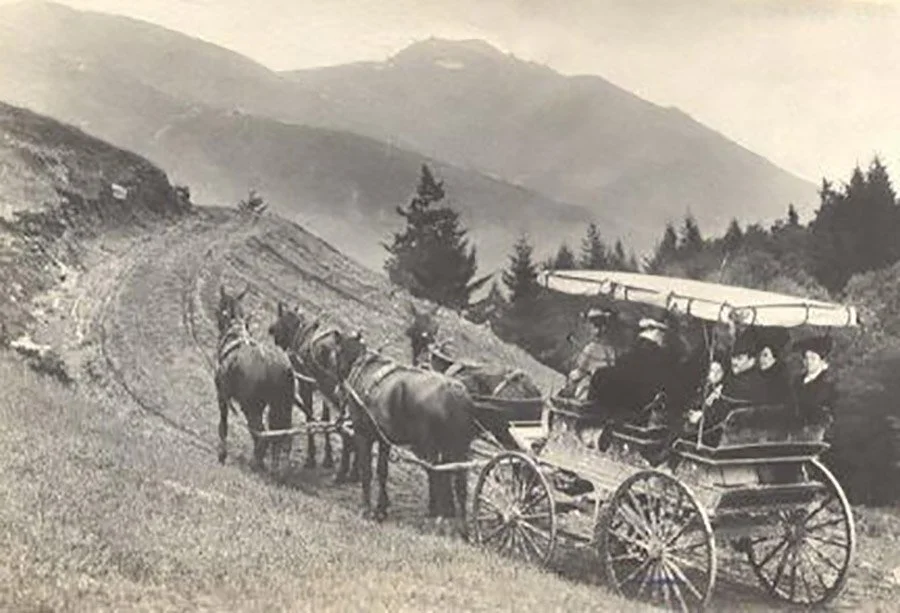
Mt. Tamalpais Stage, 1910-15. Four horsed pulled six passengers from West Point Inn on Mt. Tam to Willow Camp. Courtesy of the Stinson Beach Historical Society.
Albert Kent, after making his fortune in the meatpacking business in Chicago, moved his family to Marin in 1871. He purchased numerous pieces of land in an area that became Kent Woodlands, Kentfield today. He provided the right of way on his Mt. Tamalpais property for the building of the Mill Valley & Mt. Tam Scenic Railway in 1896. Beginning in downtown Mill Valley, it ended just below Tam’s summit. It was a wildly popular ride- over 8 miles, over 22 trestles, around 281 curves, ending at a tavern. All for $1 roundtrip. In 1904 the West Point Inn was built at the terminus. You can hike to this Inn today from Pantoll. At Kent’s suggestion, a “Gravity Car extension” with no engine, was added to Muir Woods in 1907. It became a popular thrill ride twisting around the curves. Albert Kent died in 1901.
Albert Kent’s only son, William continued to purchase land in Marin. Barry Spitz, in his book Marin, A History, said “By 1903, it was possible to walk from the Kent family home near San Francisco Bay over Tam to the ocean at Stinson Beach entirely on Kent land.” Probably the most famous and beneficial transaction William made was the purchase of 611 acres in Redwood Canyon in 1905 to save the giant redwoods from imminent logging. The 295 acres he donated to the federal government became Muir Woods National Monument, named after his friend John Muir. The remaining acres were meant to provide a right of way to expand the Mt. Tam Railway down the mountain to the ocean.
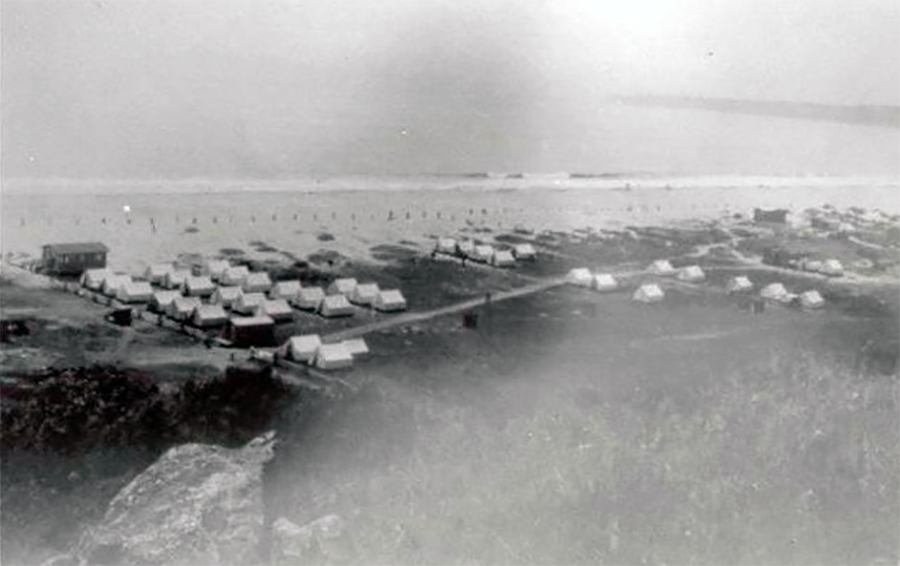
Upton Beach tents on the Calles. Courtesy of the Stinson Beach Historical Society.
In 1901 William had purchased the 62 acre sandspit with the idea of running the railway from the top of the mountain, through Stinson, along the sandspit, and across the channel on a drawbridge to Bolinas. The train would then run up the Olema Valley to Pt. Reyes Station.
Kent sold 10 acres in the middle of the spit to William Neuman to build a hotel, the first real structure on the spit. There has previously been a ferryman’s shack at the end of the spit, shortening the distance to Bolinas. The Dipsea Inn was built in 1904 to house the expected train passengers.
One dirt road ran down the length of the spit to the Dipsea Inn. Members of the San Francisco Olympic Club who had vacationed in the local area, organized the first Dipsea Race in 1905, ending at the new Inn. The next year the finish was moved to downtown Stinson. After the grueling mountain race, the last two miles on sand were intolerable. The Dipsea Race remains an annual attraction for the town. A causeway was built from Highway One across the wetland to the dirt road that ran down the spit to the Dipsea Inn. This causeway limited the flow of Easkoot’s Creek into the Bolinas Lagoon except through a narrow tidal gate. You can see remnants of the tidal gate today along the eastern edge of Seadrift.
In 1904 the Old Stage Coach Road was opened from West Point Railway terminus to Willow Camp. It was built on a railroad grade slope, also in anticipation of the railway extension. Visitors could now take a horse drawn wagon from the top of Mt. Tam down to the beach and on to Bolinas.
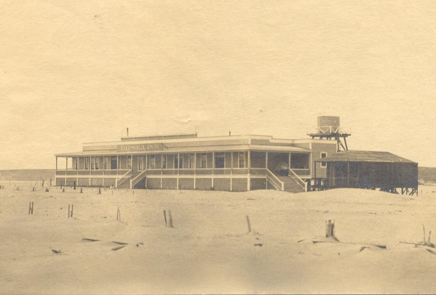
Dipsea Inn 1904-1918. Courtesy of the Stinson Beach Historical Society.
The railroad preparations were well underway when the 1906 earthquake occurred. It was clear the fault line cut right through today’s Kent Island and the end of the spit near today’s tennis courts. The sandspit was not a good route for a train line. All plans for the railway extension ceased. Willow Camp was not destined to become a major railroad resort area.
The Dipsea Inn, the only building on the sandspit, was torn down in 1918. Downtown Willow Camp and the Calles continued to host a number of tents and tent cabins, as well as a few hotels, including Airey’s Hotel, Sea Beach Hotel, and Dipsea Lodge. One of William Kent’s sons, Thomas, developed Sea Downs, a pavilion for dancing, a dining room, cottages and cabins, located near today’s lifeguard station. By 1911 motor vehicles replaced stagecoaches on the road.
Without the railroad plans, William Kent had little use for the acres he had acquired from the railroad terminus at the top of Mt. Tam to the beach. He gave 204 acres of Steep Ravine to the State Park System on March 12, 1928. He died the following day, leaving seven children.
The sandspit remained completely undeveloped.
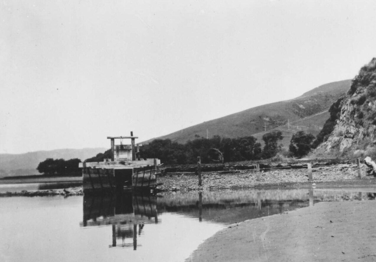
Tidal Gate on causeway to Dipsea Inn across Easkoot’s Creek, 1910. Courtesy of the Stinson Beach Historical Society.